Museum of Islamic Art & Berlin State Library
Address:
Museum of Islamic Art (Pergamonmuseum)
Am Kupfergraben 5
10117 Berlin
Germany
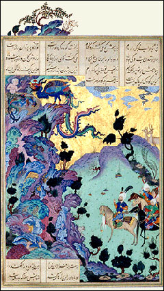
In 2010 the world celebrated the tenth centenary of the completion of the Persian 'Book of Kings'. Composed of more than 50,000 rhyming couplets, the 'Shah-nameh' is one of the greatest epics in the history of world literature. It is approximately twice as long as Homer's epics and 20 times longer than the 'Nibelungenlied'. The Persian epic poem covers a phenomenal time span, telling the entire history of the old kings of Iran, from their mythical beginnings right up to the conquest by the Arabs in 651 BCE. The epic was written by the Persian poet Ferdowsi (sometimes spelled 'Firdausi', 935-1020), who by his own estimation spent 25 years composing the work before completing it in 1010 BCE and dedicating it to the Ghaznavid ruler, Sultan Mahmud (r. 998-1020).
Berlin State Library's Oriental Department and the Museum of Islamic Art have seized upon the commemorations as an opportunity to illustrate the epic's influence in more than 100 magnificent objects, among them loans from the Museum of Asian Art, the Ethnological Museum and the German Historical Museum. The city of Berlin happens to preside over a unique collection of 'Shah-nameh' manuscripts and single sheets, many of which rank among the most spectacular treasures of Persian book art anywhere in the world. Also on display are examples of decorative art that illustrate the epic's influence on the various areas of daily life in Persia.
The exhibition provides profound insight into the world of the great kings and courageous heroes and illustrates just what a central role this piece of world literature plays for the Persian national consciousness, even today
http://www.iranchamber.com
+
نوشته شده در جمعه بیست و هشتم مرداد ۱۳۹۰ساعت 0:18 توسط mahdi
|
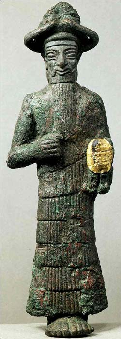 |
Elamite God, Susa, Iran
Beginning of the 2nd millennium BCE |
The Iranian Plateau did not experience the rise of urban, literate civilization in the late 4th and early 3rd millennia on the Mesopotamian pattern but the lowland Khuzestan did. It was the Elamite Civilization.
Geographically, Elam included more than Khuzestan; it was a combination of the lowlands and the immediate highland areas to the north and east. Elamite strength was based on an ability to hold these various areas together under a coordinated government that permitted the maximum interchange of the natural resources unique to each region. Traditionally this was done through a federated governmental structure.
Closely related to that form of government was the Elamite system of inheritance and power distribution. The normal pattern of government was that of an overlord ruling over vassal princes. In earliest times the overlord lived in Susa, which functioned as a federal capital. With him ruled his brother closest in age, the viceroy, who usually had his seat of government in the native city of the currently ruling dynasty. This viceroy was heir presumptive to the overlord. Yet a third official, the regent or prince of Susa (the district), shared power with the overlord and the viceroy. He was usually the overlord's son or, if no son was available, his nephew. On the death of the overlord, the viceroy became overlord. The prince of Susa remained in office, and the brother of the old viceroy nearest to him in age became the new viceroy. Only if all brothers were dead was the prince of Susa promoted to viceroy, thus enabling the overlord to name his own son (or nephew) as the new prince of Susa. Such a complicated system of governmental checks, balances, and power inheritance often broke down despite bilateral descent and levirate marriage (i.e., the compulsory marriage of a widow to her deceased husband's brother). What is remarkable is how often the system did work; it was only in the Middle and Neo-Elamiteperiods that sons more often succeeded fathers to power
ادامه مطلب
+
نوشته شده در جمعه بیست و هشتم مرداد ۱۳۹۰ساعت 0:12 توسط mahdi
|
The political structure of Iran is the Islamic Republic. The president, the members of the Parliament, the representatives of the City and Village Councils, and members of the Experts Assembly are elected in free elections through public votes. The government has three branches; namely the executive, legislative, and judiciary, each of which functions independently.
- Supreme Leader of the Islamic Revolution: The highest authority in the Islamic system of Iran is the supreme jurisprudent who determines the general guidelines of the country. The leader must also verify the president after he is elected. The leader is in turn appointed by the Assembly of Experts whose members are elected through public votes. Late Imam Khomeini, the founder of the Islamic Revolution, was the first religious and political leader of the Islamic system. The Imam managed to replace the monarchical regime with the popular Islamic Republic system of Feb. 11, 1979. Ayatollah Khomeini was deceased in 1989. After the demise of the Imam, the Assembly of Experts selected Ayatollah Seyyed Ali Khamenei as the leader of the Islamic Revolution. Ayatollah Khamenei has maintained this position ever since. He is among the top religious scholars of the Shiite world and the staunchest advocate of the Islamic Revolution. His right hand was seriously injured in a bomb incident while delivering a speech for the poor people of a district in Tehran. According to the Constitution of the republic, the leader supervises the activities of the three branches of the government.
- Assembly of Experts
- Supreme National Security Council
- Expediency Council
- President: The second highest ranking authority in the Islamic system of Iran is the president. He is the head of the executive branch and duty-bound to implement the outlines of the Constitution. The chief executive is elected through direct public votes for a period of four years. He chooses the cabinet members who should in turn win the parliament vote of confidence. Currently, the president of the Islamic Republic of Iran is Dr.Mahmoud Ahmadinejad.
- Parliament (Majlis - a.k.a. The Islamic Consultative Assembly): Some 290 Majlis deputies are directly selected by public votes. The tenure of members of the parliament is a period of four years. The president must win the vote of confidence of the parliament for appointing cabinet members.
- Guardian Council: The Guardian Council was established in a bid to ensure that Majlis ratifications comply with Islamic tenets. The body comprises six jurisprudents appointed by the leader, and six legal experts chosen by the parliament. The tenure of the members of the Council is a period of six years. All Majlis ratifications are monitored by the Guardian Council for a final verification.
- Judiciary
- Constitution: The Constitution of the Islamic Republic of Iran was ratified in Dec. 1979. It has 14 chapters and covers 177 articles. It was revised in 1989 in order to enhance presidential powers and eliminate the post of Prime Minister. The constitution confides Islamic principles of governance in cultural, social, political, and economic facets of life. The majority of people of Iran (98.2 %) voted in favor of the Islamic Republic system in a referendum held in March 1979. Based on Article 6 of the Constitution, state affairs are handled on the basis of public votes.
+
نوشته شده در جمعه چهاردهم مرداد ۱۳۹۰ساعت 23:43 توسط mahdi
|
2-3 December 1979; revised 1989 to expand powers of the presidency and eliminate the premiership Parliament (Majlis-e Shora-ye-Islami) and the Council of Guardians of the Constitution. Under the provisions of the Constitution all legislations must first be approved by the Majlis and then be ratified by the Council of Guardians. They are signed into laws by the president. Two more legislative bodies were created in 1988 by (the late IRI leader) Imam Khomeini. They were the Expediency Discernment Council (EDC) and the Council of Policy Making for Reconstruction.
Islamic Consultative Assembly (Majlis-e Shora-ye-Islami): Elections last held 18 February 2000
Judicial branch: Supreme Court
International organization participation:
CCC, CP, ECO, ESCAP,FAO, G-19, G-24, G-77, IAEA, IBRD,
ICAO, ICANN, ICC, ICRM, IDA, IDB, IFAD, IFC, IFRCS, ILO, IMF,
IMO, Inmarsat, Intelsat,Interpol, IOC, IOM (observer),
ISO, ITU, NAM, OIC, OPEC, PCA, UN, UNCTAD, UNESCO, UNHCR,
UNIDO, UPU, WCL, WFTU, WHO, WIPO, WMO, WTO
+
نوشته شده در جمعه چهاردهم مرداد ۱۳۹۰ساعت 23:37 توسط mahdi
|

Agriculture
About one-fourth of Iran is comprised of farm lands. Most of these areas are in the northwestern part of the country. The plains of Gorgan and Gonabad, Gilan and Mazandaran, Khorasan, Azarbaijan, Fars and Khuzestan are among the most fertile areas of the country. Most of the gardening activities are also carried out in these areas. The most important agro-products of the country are wheat, barley, vegetables, grain, fruits, cotton, tobacco, dates, rice, olive, corn, tea, hemp, citrus fruit, sugarcane, and sugar beet. There are fertile pieces of land and abundant water resources in the coastal plains of the Caspian Sea region and the basins of the northwestern part of the country. Citrus fruits and grapes are grown in these areas. The inhabitants of the Zagross heights and the central region are mostly farmers and stock breeders. They depend on farm and livestock products as their main source of income. Wheat, barley, sugarcane, and vegetables are grown in the plains of Khuzestan and the southern coastal areas. According to the available statistics, wheat is grown in some 6.3 hectares of the farmlands. Some 36 percent of the wheat is cultivated by water farming and the remaining 64 percent cultivated by dry farming.
Energy

Oil:
- Iran ranks sixth in the world and fourth in the Middle East in terms of oil (petroleum) resources. Iran is among the top four countries of the world, which will have oil resources for the next 70 years. It produces about 4.5 million barrels of oil per day, some 2.9 million of which are exported to other countries.

Natural Gas:
- Iran ranks second in the world in terms of its gas reserves (23 trillion cubic meters). Most of these reserves are located in Aghajari (Khuzestan province), Kangan (Bushehr province), the Qeshm Island (Hormuzgan province), and Khangiran-e-Sarakhs (Khorasan province). Over two third of the urban and rural areas have access to gas pipelines. Over 17 percent of the power plants of the country operate on gas.
Coal:

- The main coalmines are situated in the Alborz region and the provinces of Khorasan and Kerman. Every year, over 1.5 million tons of coals are exploited for steel production. The largest coalmine of the country (over one million tons of coal reserves) is located in the village of Parv in the southwestern part of Tabas. Iran ranks first in the Middle East in terms of coalmines.
Electricity:

- Some 87 percent of the country's electrical power is produced by power plants which operate on natural gas, furnace oil, and gas oil. This is due to the fact that fossil fuel is found in abundance in Iran. Due to the water shortage in the country, only 13 percent of the power plants operate on steam. The recommended voltages for home appliances and industrial machines are 220 V and 380 V respectively. Iran is working on the utilization of wind and atomic energies in order to boost its electrical power system. Iran currently exports electrical power to Turkey and the Republic of Azerbaijan.
Currency


The monetary unit in Iran is the Rial. It is available in coins of 5, 10, 50, 100, 250, and 500 Rials; and banknotes of 100, 200, 500, 1000, 2000, 5000, 10000, and 20000 Rials. Although Rial is the official currency in everyday life people usually deal inToomans. Each Toman is equivalent to 10 Rials. All the Iranian banks may provide Iranians and foreigners with traveler's checks of 200,000; 500,000; 1,000,000; 2,000,000; and 5,000,000 Rials with no banking charge in order to facilitate the transport of money.
+
نوشته شده در جمعه چهاردهم مرداد ۱۳۹۰ساعت 23:33 توسط mahdi
|

Pilgrimage to the shrines of Imams is a specific Shia custom. The most important shrines in Iran are those for the Eighth Imam in Mashhad and for his sister Fatima in Qom. There are also important secondary shrines for other relatives of the Eighth Iman in Rey, adjacent to south Tehran, and in Shiraz. In virtually all towns and in many villages there are numerous lesser shrines, known as imamzadehs, which commemorate descendants of the imams who are reputed to have led saintly lives. Shia pilgrims visit these sites because they believe that the imams and their relatives have power to intercede with God on behalf of petitioners. The shrines in Iraq at Karbala and An Najaf are also revered by Shias.
There are more than 1,100 shrines that vary from crumbling sites associated with local saints to the imposing shrines of Imam Reza and his sister Fatima in Mashhad and Qom, respectively. These more famous shrines are huge complexes that include the mausoleums of the venerated Eighth Imam and his sister, tombs of former shahs, mosques,madrasehs, and libraries. Imam Reza's shrine is the largest and is considered to be the holiest. In addition to the usual shrine accoutrements, Imam Reza's shrine contains hospitals, dispensaries, a museum, and several mosques located in a series of courtyards surrounding his tomb. Most of the present shrine dates from the early fourteenth century, except for the dome, which was rebuilt after being damaged in an earthquake in 1673. The shrine's endowments and gifts are the largest of all religious institutions in the country. Traditionally, free meals for as many as 1,000 people per day are provided at the shrine. Although there are no special times for visiting this or other shrines, it is customary for pilgrimage traffic to be heaviest during Shia holy periods. It has been estimated that more than 3 million pilgrims visit the shrine annually.
Visitors to Imam Reza's shrine represent all socioeconomic levels. Whereas piety is a motivation for many, others come to seek the spiritual grace or general good fortune that a visit to the shrine is believed to ensure. Commonly a pilgrimage is undertaken to petition Imam Reza to act as an intermediary between the pilgrim and God. Since the nineteenth century, it has been customary among the bazaar class and members of the lower classes to recognize those who have made a pilgrimage to Mashhad by prefixing their names with the title mashti.
The next most important shrine is that of Imam Reza's sister, Fatima, known as Hazarat-e Masumeh (the Pure Saint). The present shrine dates from the early sixteenth century, although some later additions, including the gilded tiles, were affixed in the early nineteenth century. Other important shrines are those of Shah Abdol Azim, a relative of Imam Reza, who is entombed at Rey, near Tehran, and Shah Cheragh, a brother of Imam Reza, who is buried in Shiraz. A leading shrine honoring a person not belonging to the family of Imams is that of the Sufi master Sayyid Nimatollah Vali near Kerman. Shias make pilgrimages to these shrines and the hundreds of local imamzadehs to petition the saints to grant them special favors or to help them through a period of troubles.
Because Shias believe that the holy Imams can intercede for the dead as well as for the living, cemeteries traditionally have been located adjacent to the most important shrines in both Iran and Iraq. Corpses were transported overland for burial in Karbala in southern Iraq until the practice was prohibited in the 1930s. Corpses are still shipped to Mashhad and Qom for burial in the shrine cemeteries of these cities.
The constant movement of pilgrims from all over Iran to Mashhad and Qom has helped bind together a linguistically heterogeneous population. Pilgrims serve as major sources of information about conditions in different parts of the country and thus help to mitigate the parochialism of the regions.
+
نوشته شده در جمعه چهاردهم مرداد ۱۳۹۰ساعت 23:28 توسط mahdi
|
Jafari Shia of Islam has been the official religion of Iran since the 16th century. An estimated 93 percent of all Iranians follow Shia Islam, and nearly all are members of the Jafari group.Since Jafaries believe there are 12 legitimate successors, or imams, to Prophet Mohammad, they are often called Twelvers (Asna Ashari).The small remaining part of the population belongs to other Islamic denominations, primarily Sunni Islam. Iran also has small communities of Armenian and Assyrian Christians, Jews, and Zoroastrians
+
نوشته شده در جمعه چهاردهم مرداد ۱۳۹۰ساعت 22:35 توسط mahdi
|
Iranians have a high ambition and generous behavior in their lives. They like living well and simple at the same time. Through many years, this way of thinking has led the Iranians to create many handmade works that are used in everyday life and have their own markets despite all many advances in making various products. Iranian handicrafts have a special position in the world. One of the evident characteristics that has put the handicrafts in such a position is the glorious reflection and splendors that the Iranian artists have understood them so that the colors and their combinations have deep philosophical, mystic and literary meanings in the Iranian handicrafts and traditional arts. The extensive tribal and cultural variety that exists in Iran is the reason why people of each Iranian tribe and race have made beautiful handicrafts according to the culture and conditions of the climate of the place they live in. For example carpets of each place of Iran has a special design; the design of Tabriz carpet has close relationship with the culture and art of Azeri people; carpet designs of Kashan, Qom, Esfahan and Kermany are mostly related to the thought of the people in desert and desert edges. Inlaid work and enamel dishes are the work of talented artists of Esfahan and Shiraz, and colorful coarse carpets are woven by women of tribes of Chaharmahal and Bakhtiari, Kohgiloyeh and Boyerahmad and Ilam and Ardebil. Earthenware with prehistory impressions and designs are made by Kalpoorgan women in the heart of Sistan va Baloochestan desert, and beautiful and colorful earthenware with Islamic designs and impressions are made in Meybod and Lalejin. In fact Iran is the home to handicrafts, a land in which one can see an extensive variety of fascinating handmade works in each corner from Mazandaran Sea to Persian Gulf. Iran, Land of Festivals and Customs. Diverse tribes, religions and cultures in Iran have all made Iran a land of festivals and customs.
Here you get familiar with the handicrafts and souvenirs of some provinces :
Handicrafts and Souvenirs

The main handicrafts pursued in the province are engraving on copper and brass, Khatam (inlaid), wood carvings and basket making, glassware, painted glass, ‘Zeelu’ or kind of carpet, leather paintings, carpet weaving, pottery making, weaving of mats, hand woven or knitted articles, batik purist, jajeem or loosely woven woolen cloth, Kilim or coarse carpet, satchel making, dyeing and weaving. Antiques can be obtained from Manuchehri Avenue which forms the center for such articles. Handicraft centers are located in Taleqani Avenue and Ostad Nejatollahi Avenue. Carpets are available in Bazaar-e-Bozorg of Tehran and Ferdowsi Avenue. Books can be bought from shops apposite the University of Tehran.

The province of Esfahan is reputed for its handicrafts and can be considered as an important sector in this regard. Besides its own local products, specialties from other provinces of Iran are also produced here. Since this province is highly favored by tourists, it is an obvious fact that handicrafts play a vital part in this area. The most important of these are the following: Carpet weaving, brocade weaving, kilim (or a coarse carpet), enamel work, khatam (inlaid work), engraving on metal, silver work, jewelry making, ceramic and tiles and types of sweetmeats, such as 'gaz' and 'souhan'.

Located in Ardebil (a city of Ardebil province)
Ardabil province is well known for its carpets as well as sweets such as Halva. The souvenirs of the province are: wickerwork, wool hand-woven cloth, coarse rug, felt carpet, different metal and wooden works, inlaid, silver objects, earthenware, local shoes, and other handicrafts.

Since long the tribes of Kohkiluyeh Va Boyer Ahmad province, used to make several types of handicrafts and hand woven products. The existence of lots of raw materials, such as wool, has provided a good scope that enables people to create articles in different types, colors, and at a desired quality. These articles are in great favor. 90% of these handmade products are marketed out of this province.
There are several types of different woven crafts. Some of them are knitted, such as rugs, cushions, satchels and Kilims . Others are carpets, gabeh, Kilims, (or coarse carpets), gloves and other handicrafts that are made by the tribes of this province which are in demand.

The most important handicraft of the province is earthenware and ceramics, and a place called 'Lalejin' (30 km. north of Hamadan) is famous for this handicraft. Besides earthenware and ceramics, there are the followings - carpet and 'Kilim' weaving (or a coarse carpet), clothing (mainly to do with the nomads), 'jajeem' (or a loosely woven woolen material), leather work, 'geeveh' (a local foot-ware), sweet-meats and grape syrup.

Located in
Ilam (a city of
Ilam province)
The Ilam province is a tribal region and its handicrafts specially embossed Kilim is famous nationally. The most important handicrafts of the province are: wickerwork, coarse carpet, silk products, rug, felt carpet, wooden products and…
Ilam province, like the other provinces of the country, has its own especial souvenirs like local chewing gum (the gum of Persian turpentine tree), local sweets,candy and…

Located in Kerman (a city of Kerman province)
The handicrafts and souvenirs of the province of Kerman are as follows:
A traditional embroidery known as patteh, carpets, rugs, jajeems, Kilims (a coarse carpet), satchels, and other hand woven articles. Caraway seeds and pistachio of Rafsanjan and Kerman are best of the main items of this province.
Kermanshah since long has been one of the most famous handicrafts centers of Iran. The most important handicrafts and gifts of the province that mainly are produced by the villagers and tribes are:
Carpet, Kilim, Jajims or a loosely woven material, Kitchen implements, traditional kitchen wares and wooden articles, Giveh (local shoes), metal engraving, glassware, felt and leather products, and its famous sweet-meat mainly Kak.

Located in
Qom (a city of
Qom province)
In Qom province and more so in its rural areas handicrafts play an important part. Even though today it is to a lesser degree, but is still a means of earning a livelihood. The most important of these handicrafts are: carpets, brick and ceramic work, latticed work, a special type of sweet known as Sohan, rosaries, vessels of stone and gypsum, decorative articles, porcelain, silk carpets and fruits like pomegranate and fig.

Handicrafts in this province are the following: Kilims or coarsely woven carpets, a variety of calico or 'block printed' articles, earthenware, ceramics, and hand woven articles can be picked up at the handicrafts center and bazaars.

These plain knives and a variety of pocket knives and switch blades, carpets, 'Charoq' (a local type of women shoe) filigree work, silver and a variety of 'Kilim' (a coarse carpet or rug) and 'jajim' or (loosely woven woolen carpet).
+
نوشته شده در جمعه چهاردهم مرداد ۱۳۹۰ساعت 22:33 توسط mahdi
|
the "Official language (of Iran)... is Persian...[and]... the use of regional and tribal languages in the press and mass media, as well as for teaching of their literature in schools, is allowed in addition to Persian." Persian serves as a lingua franca in Iran and most publications and broadcastings are in this language.
Next to Persian, there are many publications and broadcastings in other relatively popular languages of Iran such as Azeri, Kurdish and even in less popular ones such as Arabic and Armenian. Many languages originated in Iran, but Persian is the most used language. Persian belongs to Iranian branch of the Indo-European family of languages. The oldest records in Old Persian date to the Achaemenid Empire,[215] and examples of Old Persian have been found in present-day Iran, Iraq, Turkey and Egypt.
In the late 8th century, Persian was highly Arabized and written in a modified Arabic script. This caused a movement supporting the revival of Persian. An important event of this revival was the writing of the Shahname by Ferdowsi (Persian: Epic of Kings), Iran's national epic, which is said to have been written entirely in native Persian. This gave rise to a strong reassertion of Iranian national identity, and is in part credited for the continued existence of Persian as a separate language.
بسی رنج بردم در این سال سی
عجم زنده کردم بدین پارسیFor thirty years, I suffered much pain and strife
with Persian I gave the Ajam verve and life | ” |
Persian beside Arabic has been a medium for literary and scientific contributions to the Islamic world especially in Anatolia, central Asia and Indian sub-continent. Poetry is a very important part of Persian culture. Poetry is used in many Persian classical works, whether from literature, science, or metaphysics. Persian literature has been considered by such thinkers as Goethe as one of the four main bodies of world literature.[216]
The Persian language has produced a number of famous poets; however, only a few poets as Rumi and Omar Khayyám have surfaced among western popular readership, even though the likes of Hafez, Saadi, Nezami[217] Attar, Sanai, Naser Khusraw, Jami are considered by many Iranians to be just as influential. The books of famous poets have been translated into western languages since 1634. An example of Persian poetic influence is the poem below which is widely popular:
| “ | بنى آدم اعضای يک پیکرند
که در آفرينش ز يک گوهرند
چو عضوى به درد آورد روزگار
دگر عضوها را نماند قرارOf one Essence is the human race
thus has Creation put the base
One Limb impacted is sufficient
For all Others to feel the Mace
| ” |
+
نوشته شده در جمعه چهاردهم مرداد ۱۳۹۰ساعت 22:31 توسط mahdi
|
Iran is divided into thirty one provinces (ostān), each governed by an appointed governor (استاندار, ostāndār). The provinces are divided into counties (shahrestān), and subdivided into districts (bakhsh) and sub-districts (dehestān). Most internal migrants have settled near the cities of Tehran, Isfahan, Ahvaz, and Qom.
Tehran , is the largest city in Iran and is the Capital. Tehran is home to around 11% of Iran's population.
Mashhad, is the second largest Iranian city and the centre of the province of Razavi Khorasan. Mashhad is one of the holiest Shi'a cities in the world as it is the site of the Imam Reza shrine. It is the centre of tourism in Iran, and between 15 and 20 million pilgrims go to the Imam Reza's shrine every year.
Another major Iranian city is Isfahan , which is the capital of Isfahan Province. The Naghsh-e Jahan Square in Isfahan has been designated by UNESCO as a World Heritage Site. The city contains a wide variety of Islamic architectural sites ranging from the 11th to the 19th century. The growth of the suburban area around the city has turned Isfahan into Iran's second most populous metropolitan area (3,430,353).
The fourth major city of Iran is Tabriz , the capital of the East Azerbaijan province. It is also the second industrial city of Iran after Tehran. Tabriz had been the second largest city in Iran until the late 1960s and one of its former capitals and residence of the crown prince under the Qajar dynasty. The city has proven extremely influential in the country’s recent history.
The fifth major city is Karaj , located in Alborz province and situated 20 km west of Tehran, at the foot of the Alborz mountains; however, the city is increasingly becoming an extension of metropolitan Tehran.
The sixth major Iranian city is Shiraz , it is the capital of Fars Province. The Elamite civilization to the west greatly influenced the area, which soon came to be known as Persis. The ancient Persians were present in the region from about the 9th century BC, and became rulers of a large empire under the Achaemenid dynasty in the 6th century BC. The ruins of Persepolis and Pasargadae, two of the four capitals of the Achaemenid Empire, are located in or near Shiraz. Persepolis was the ceremonial capital of the Achaemenid Empire and is situated 70 km northeast of modern Shiraz. UNESCO declared the citadel of Persepolis a World Heritage Site in 1979.

| Ardabil | Bushehr | Chaharmahal va Bakhtiari | East Azarbaijan | Esfahan |
| Fars | Gilan | Golestan | Hmaedan | Hormozgan |
| Ilam | Kerman | Kermanshah | Khuzestan | Kohkiloyeh va Boyerahmad |
| Kurdestan | Lorestan | Markazi | Mazandaran | North Khorasan |
| Qazvin | Qom | Razavi Khorasan | Semnan | Sistan va Baluchestan |
| South Khorazan | TEHRAN | West Azarbaijan | Yazd | Zanjan |
+
نوشته شده در جمعه چهاردهم مرداد ۱۳۹۰ساعت 22:27 توسط mahdi
|
Although Iran is situated in the northern temperate zone, it has diverse climatic conditions due to various reasons. The direction of its mountains, its being adjacent to the hot and arid Saudi Arabian deserts, and its distance from the seas is the most important reasons behind Iran's diverse climatic conditions.
One distinct climatic feature of Iran is the intense temperature gradients, which at certain instances exceed 40 degrees centigrade (104°F). The warmest areas of the country are the coastal regions of the Persian Gulf and the Sea of Oman as well as the pits in Loute and Sistan.In the summertime, the temperature in these areas exceeds 45 degrees centigrade (113°F). This is while the temperature in the northwestern and western parts of the country as well as the northern mountainous areas may reach over minus 30 degrees centigrade (-22 °F) in winters. It must also be noted that the annual precipitation level varies from zero to 2000 millimeters. The highest level of annual precipitation takes place in the Caspian Sea coastal areas as well as the northern and northwestern parts of the country. The lowest level of annual precipitation takes place in the southern and eastern parts of the country and the central desert region.
Classification of the climates:
- Warm and Humid: Provinces of Gilan, Mazandaran, and Golestan
| 
|
- Warm and Dry: Provinces of Khuzestan, Ilam, Bushehr, Hormozgan, and south of Sistan and Baluchestan
| 
|
- Desert and Half-desert: Provinces of Qom, Esfahan, Yazd, Kerman, Sistan and Baluchestan, Semnan, South Khorasan, and Khorasan Razavi.
| 
|
- Mountainous: Provinces of Tehran, Markazi, Qazvin, Lorestan, Kohgilooyeh and Boirahmad, Chahar-Mahal and Bakhtiari, Kermanshah, and North Khorasan are in the mountainous areas of the country.
| 
|
- Moderate Cold: Provinces of West and East Azarbaijan, Ardebil, Kurdestan, Hamedan and Zanjan
| 
|
+
نوشته شده در جمعه چهاردهم مرداد ۱۳۹۰ساعت 22:26 توسط mahdi
|
Iran is a mountainous country. Over one half of its area is made up of mountains and heights; some one-fourth of its territories are desert regions and the remaining one fourth is comprised of farmlands. The other one was the main Silk Road which connected the cities in the northern areas of Iran, such as Kermanshah, Hamedan, Rey, Gorgan, Neyshabour, and Toos to Central Asia (Marv, Samarqand, and Bukhara), China, and Japan.
The Iranian plateau comprises various highlands, over two-thirds of which are above 10000 meters high from the sea level. From a topographical point of view, Iran comprises several ranges. The Koupehdagh, Aladagh, and Binaloud originate from the northeastern parts of the country and extend to eastern Alborz heights in the southern Caspian Sea region.

The Alborz Range, which is made up of the three eastern, central, and western sections, covers all the northern areas of the country all the way to the Aras River and the Ararat heights in northwestern Iran. Damavand is the highest volcanic peak of the country with 5671 meters high. Alamkouh is the most important glacier of the country. This peak is 4820 meters high and is located in Central Alborz.

The Zagross Range extends over all the western and southwestern areas of the country, ranging from the borders with Turkey all the way down to the vicinity of the Strait of Hormoz in the Persian Gulf. These heights are mainly remnants of the sediments of the Mesozoic and cover almost half of Iran. The Zagross Range has perpetually protected the central government against tribal attacks. Two volcanic peaks, namely Sahand, which is 3710 meters high, and Sabalan, which is 4821 meters high, are located in this region. The Zagross Range ends to the Makran Mountains (along the shores of the Sea of Oman) in the south. The Makran Mountains extend all the way to the Iran-Pakistan borders. The only lowlands of the country are in the central and eastern regions, comprising the central pits, the area known as Loute and Nahbandan fissures.

The Loute Pit, the area known as Jazmourian, the central salty desert areas, and the sandy Loute areas are located in the lowlands. The most important heights in this region are the Sistan Mountains and the volcanic peak of Taftan which is 4042 meters high.
+
نوشته شده در جمعه چهاردهم مرداد ۱۳۹۰ساعت 22:24 توسط mahdi
|
 Iran is located in the northern hemisphere in southwest Asia. It is situated in the Iranian plateau between 25 to 40 degrees northern latitude and 45 to 63 degrees eastern longitude. Its southern areas are situated in the equatorial region and its northern areas in the northern temperate zone. Iran's area is 1,648,195 square kilometers. Its northern neighbors are Turkmenistan, the Republic of Azerbaijan, and Armenia while the Caspian Sea is also located in its north. Pakistan and Afghanistan are located in the east of Iran and Turkey and Iraq in the west. The Persian Gulf and the Sea of Oman are situated in the southern parts of the country. Iran's borders extend 7,774 km, some one-third of which are sea borders.
Iran's borders in the southern coastal areas of the Caspian Sea and the northern coastal areas of the Persian Gulf and the Sea of Oman are 663 km and 1,952 km long respectively.

From a geographical point of view, no country in the Caspian Sea, Central Asia, and Caucasus Region has access to free water, except Iran. This is while the regional economies mainlydepend on the production and export of oil and imports of various goods from the rest of the world. Since the Caspian Sea is located among Iran, Russia, Azerbaijan, Kazakhstan, and Turkmenistan, the regional trade activities can thrive meaningfully. Furthermore, these countries believe that their economic, cultural, and social progress is contingent upon their access to the international markets.
Due to its unique geographical location and cultural and historical commonalities with the regional countries, Iran is the best venue for ensuring an international trade link in the region. Iran has the best transit facilities in the region; it has high security and is the shortest and least expensive route for the transport of regional energy. It also has access to the energy transport technology. Until 1998, the proven oil reserves of the region were estimated at 154.4 billion barrels while its proven gas reserves stood at 48.5 trillion cubic meters. These are Iran's indisputable economic advantages.

For some 4000 years, Iran has been the hub of trade and culture in the East. It has acted like a sturdy bridge connecting the East to the West. Two commercial roads of Silk and Spices pass through Iran. The countries in Central Asia and the Caucasus as well as Russia depend on Iran for access to the free waters of the world (North-South link). Iran is the land where the transfer of science and technology from the East to the West and vice versa has become a reality . Iran also has maintained its trade security throughout the years. Interestingly enough, Marco Polo, the famous Venetian traveler and author, traveled to China via Iran.
 The Persian Gulf and the Sea of Oman
- The Persian Gulf is a semi-closed sea, which is surrounded by Iran, Iraq, Kuwait, Saudi Arabia, Qatar, Bahrain, the UAE, and Oman. It is the greatest link among Europe, Africa, as well as South and Southeast Asia. The strategic Strait of Hormoz in the Sea of Oman essentially links the regional countries to the Indian Ocean, the Atlantic Ocean, the Red Sea, and the Mediterranean Sea. The population of the Persian Gulf area is about 100 million. Most of these people are consumers of Western and Japanese industrial products. The regional countries' main source of revenue is oil and gas. Every day about 15 to 16 million barrels of oil are exported to different parts of the planet from the regional countries via the Strait of Hormoz alone. The U.S., Western European countries, and Japan procure some 30, 60, and 76 percents of their oil needs respectively through the Persian Gulf region. The total regional imports and exports amount to over 145 billion dollars, some 80 billion dollars of which are related to the exports of crude minerals, particularly oil and gas. Over eight million foreign skilled and semi-skilled laborers are employed in the regional countries.

In the Middle of Silk Road
Many edifices, aqueducts, caravansaries, bridges, mosques, traditional bathhouses and bazaars still remain in the mountainous and desert areas of the country marking the type of services that Iranians provided for globetrotters and businessmen throughout history. Two main highways of the Silk Road which played an important role in promoting cultural and commercial bonds between the East and the European countries, passed through Iran. Many edifices, aqueducts, caravansaries, bridges, mosques, traditional bathhouses and bazaars still remain in the mountainous and desert areas of the country marking the type of services that Iranians provided for globetrotters and businessmen throughout history. Two main highways of the Silk Road which played an important role in promoting cultural and commercial bonds between the East and the European countries, passed through Iran. Iranian history and civilization are among its great tourism attractions. The Silk Road, since its birth in the second half of the second century B.C. until the early years of the 20th century, passed through the Iranian territories. Iran's unique regional and global geopolitical situation has provided numerous opportunities for foreign businessmen and tourists of many countries. Throughout the years, Iran provided services to groups of tourists and businessmen who used its ports and islands in the Sea of Oman, the Persian Gulf, and the Caspian Sea as well as the Silk Road for cultural and economic interactions.
http://en.iran.ir/en_news/location.html
+
نوشته شده در جمعه چهاردهم مرداد ۱۳۹۰ساعت 22:23 توسط mahdi
|
The plain of Iran is among the most ancient civilizations of the world. Some objects d'art discovered by archeologists in Iran date back to 10,000 B.C. The hunting tools and stone articles discovered in various caves, such as the Pabda Cave in the highlands of Chaharmahal & Bakhtiari province, reveals that human life existed in the Iranian plateau during the Paleolithic Period.
The metallic articles discovered from the Gun and Lullubi people in the northern areas of Zagross Mountains show that these people knew how to use metal in 3,000 B.C. During this period, villages and small towns were also established. The examples are the Sialk Village (near Kashan) and the Burnt City (near Zabol).
The most important civilization that existed in Iran before the settlement of Aryans was the Illamit in the plain of Khuzestan, in particular in the city of Susa. The Illamits called their territory and government the Hatami.

The Illamit Dynasty was established in 3000 B.C. The Illamit Dynasty engaged in several wars with the Mesopotamian civilization (Somecs and Babylonians). The turning points of these wars was in the 13th century B.C. when the Illamits seized Mesopotomia and captured the stone column on which Hamurabi Law was inscribed and brought it to Susa, the capital city of the Illamit government.
The kings of Ilam constructed several temples in Susa, the most important of which are Zigorat and Choghazanbil in the present day Khuzestan province.
In 650 B.C., Ashur Banipal,the King of Ashur, attacked Ilam and completely ruined Susa. Banipal's attack coincided with the period when Aryans were re-expanding their territories--a move which had actually started in the 15th century B.C.

The Aryans had decided to move from the southern areas of Russia towards Iran since the number of their cattle had increased and also because of the cold weather. The Aryans, who are classified as Indo-Europeans, separated into two groups after immigrating to Iran. One group eventually settled in Europe and the other set out for India via Iran.
In the beginning years of the 2nd millennium B.C., a group of the Indo-European race, who had immigrated to the south, settled in the northern parts of Iran, along the rivers Zion and Jihon. Because this group could use horses in wars, they took over the entire Ilamit territories all the way down to the Persian Gulf and the Sea of Oman. They also conquered India. This group called themselves the Aryans.

The word Aryanl iterally means genuine, noble and honest. The Aryans settled all over Iran in tribal groups and bred cattle for living. Their major tribes were the Medes (in the west), the Perse (in the south) and the Parthes (in the southeast).
The Aryans called their enemies "The Devil". They were skillful horse riders and brave fighters. During this period, the king of Aryans was Jamshid who called on his people to worship Ahuramazda (literally meaning God in ancient Persian). He also founded the custom of Norouz (The Iranian New Year which marks the beginning of spring). During Jamshid's reign, Zoroaster declared his prophecy. He aimed to ameliorate the beliefs of Iranians and also unite all Aryans.
Almost all Iranian tribes, except Sokahas, embraced Zoroastrianism. A group of Sokahas, called Touranis, fought several wars with the followers of Zoroaster. During one of these battles the ourani tribesmen killed Zoroaster.

Meanwhile one of the cfieftains of the Medes, Dia-Eko, called for solidarity among his tribesmen in a bid to protect the sovereignty of Iran in the west and to also prevent the attack of the Ashurs. He constructed the Fort of Hegmataneh in the present day city of Hamedan to be well- prepared for all contingent attacks. This was the prelude to the establishment of the Median Dynasty.
In 550 B.C., Cyrus, a member of the Passargad tribe revolted against Ajdahak, the Median monarch of the time, in protest to the dominance of the aristocratic class. Cyrus, whose mother was Ajdahak's daughter, managed to unite 10 Persian tribes and overthrew the Median Dynasty. This marked the birth of the Achaemenian Dynasty.
Cyrus ruled over the Persian Empire until 530 B.C., Daruis the First, the monarch who succeeded Cyrus, constructed the Parseh Palaces complex (Persepolis) in the northern part of Shiraz. The epigraph of Ganjnameh in Hamedan, which was inscribed in the three scripts of Old Persian, Illami and Babylonian, also belongs to the era of Darius's reign

In 351 B.C., Alexander the Great attacked the Achaemenian Empire and conquered Persia. Alexander set all the palaces and religious centers of the Persians on fire and looted them of their belongings and wealth. To be noted that the tombs of Darius I and Ardeshir I (the founder of the Sassanid Dynasty) are located in Naghsh-e Rostam (Necropolis), Fars province.
Alexander died in the ancient city of Babylon in 323 B.C.. Solukus, one of Alexander's commanders, succeeded him and ruled over Iran for over 80 years.
The Iranian aristocrats and Macedonian commanders held the top posts in the Solukid political modus operandi. In 248 B.C., Ashk, a Parthian hero, declared a war against the Solukids.
The battle lasted for over one hundred years. Tirdad (Ashk II) overthrew the Solukid monarch, Antiokhus III, in 140 B.C. and established the Arsacides Dynasty. The Solukids retreated to the western part of Euphrate. The major problem facing the Arsacides was that the governments of the provinces of Persia , Azarbaijan and Armenia did not obey them. In a bid to win these states' trust and also to collect taxes from them, the Arsacides estab I shad the Count 1 of Mahestan, which comprised of the personalities of the country. With the birth of Christianity during the rule of Farhad N, the 14th Arsacides monarch, the teachings of Jesus Christ spread all over the territory of Rome. The peak of Zoroastrianism in Iran was the Arsacides era when many fire temples were constructed, including the two temples of Anahita in the cities of Kangavar and Estakhr. Many Iranianheroes created epics during the rule of the Arsacides, including Goodarc, Giv, Bijan and Rosatm-e-Zal.
Ferdowsi the great poet of the 10th and 11th centuries A.D., wrote poems on these heroes' lives in his masterpiece Shahnameh (The Story of Kings). In 224 A.D., Ardeshir the son of Babak, overthrew the Arsacides Dysnaty through the support of the aristocrat class of the time. Ardeshir officially founded the Sassanid Dynasty in 226 A.D. His son and successor, Shapour I, declared many wars against-the Roman Empire. In one of these wars, he captured Valerian, the Roman emperor. During Shapour's reign, Zoroastrianism was recognized as the official religion of Iranians and the Avesta (the sacred book of Zoroastrians) was compiled.
The most important kings of the Sassanid Dynasty were Bahrain IV (also known as Bahram-e Gour), Anoushiravan, Hormuz-and Khosrow Parviz. Tatl-e Bostan, an ancient monument in Kermanshah, was built during the rule of the Sasganid Dynasty.
With the expansion of Islam in Saudi Arabia, Prophet Mohammad (P.B.U.H.H.P.) in a letter to Khosrow Parviz called on him to become a Muslim. However, the Iranian king tore off the letter out of sheer arrogance. After the death of the prophet and during the nxle of Abu Bakr, the Muslim caliph (Abu Bakr was considered to be the successor of the prophet according to the Sunni faith), Khalid bin Valid, the commander of the Arab Muslim army, reached the frontiers of Iran in 626 A.D. Yazdgerd III, the Sassanid monarch of the time, ordered his army to fight the Muslisms under the commandership of Rostam Farrokhzad. In 635 A.D., the Arab Army defeated the Iranians in the war of Qadessieh. Madaen, the capital city of the Sassanid Dynasty, which comprised of seven other cities, including Tisfoon, was seized by the Muslims. In 642 A.D., Yazdgerd III was completely defeated by Muslims. He escaped to Khorasan and was killed by one of his opponents in 651 A.D. With the fall of the Sassanid Dynasty in 652 A.D., the Islamic period started.
http://www.iranembassy.gr/eng/about_iran_Islamhistory.htm
+
نوشته شده در جمعه چهاردهم مرداد ۱۳۹۰ساعت 22:20 توسط mahdi
|

After the defeat of the Iranian Kingdom by Arabs , Islam prevailed all over the territories formerly ruled by the Arsacides. The Bani Omayyeh caliphs expanded their territories from the coastal areas of the Mediterranean Sea to Spain in the west all the way up to China in the east. The Bani Omayyeh caliphs ruled over Iran for some 91 years. Intoxicated with the victory of Muslims over the two great governments of Iran and Rome, the Bard Omayyeh caliphs arrogantly developed the notion that these victories over non-Arabs had materialized due to the bravery of the Arabs.
Therefore, they chose to prefer Arabs to non-Arabs in the Islamic lands, actually paving the grounds for the revolt of other peoples. Iranians, in particular, were subjected to a more blatant prejudice. Finally, the Iranians who could not suffer the tyranny of the Bani Omayyehs any longer, and also in a bid to revenge the martyrdom of Imam Hossein (P.B.U.H.) in 682 A.D. by Yazid bin Moavieh's army, united with the opposition groups led by Mokhtar and revolted against the Bani Omayyeh. In 101 (AH), bin Abbass, one of Abdulmotalleb's sons, assumed the leadership of the Shiites and essentially paved the grounds for the establishment of the Abbassian Dynasty who ruled over Iran for a long time.

The Shiites, the followers of Imam Ali (P.B.U.H.), were subjected to the most oppression during the reign of the Abbassian. As a result, many Shiites emigrated from Iraq to Rey, Qazvin, Gilan, Tabarestan and Jorjan. These descendants of = Imam Ali (P.B.U.H.), most of whom were Shiites of Zeidi, established the Alavian Dynasty and took over the governments of Sistan, Khorasan, Kerman and Fars. The Abbassian ruled over Iran until 250 (AH). The most important dynasties which ruled over Iran until the Mongolian Era were the Saffarian, the Samanides, the Ghaznavid,the Gourkanian, the Seljukian,the Atabakan and the Kharazmshahian. These dynasties ruled over Iran for over 350 years.

The Mongols attacked Iran in 616 (AH) (or 1237 A.D.). The Mongols fought many wars with the Karazmshahian. Finally. Chengiz Khan the Mongol, as the ruler of Mongolia, signed a treaty with the Kharazmshahian monarch of the time, in 615 (AH) in a bid to promote peace and friendship between the two nations of Mongolia and Iran. In the wake of the conclusion of the agreement, a large number of merchants set out for the Euphrate. In the meantime, Qayer Khan, one of the shah's mother's friends, convinced the sultan that these merchants were Chengiz Khan's spies.

The shah killed all the merchants except one who could escape and confiscated their properties. Chengiz, who had been shocked, sent a special envoy to the court of the Iranian king to extradite Qayer Khan. However, the shah did not agree to the extradition and even killed Chengiz's special envoy. This led to the attack of Chengiz's large army against the Islamic territories in 616 (AH) (or 1237 A.D.). Although the Mongols ruled over Iran from 620 (AH), their first ambassador to Iran, Holakoukhan, officially settled in Iran in 651 (AH). Some 17 Mongolian Ilkhans ruled over Iran for some 105 years (up to 756 (AH) (or 1377 A.D.)). The most prominent poets and scientists of this era were Mowlavi, Saadi, Hafez, Joveini, Hamdallah, Mostowfi, Khajeh Nassir Toussi, Attar and Khajou Kermani.

After the end of the rule of Illcanian over Iran, the dynasties of Mozaffarian and Teymourian reigned over the Iranian territories. The Safavid Dynasty was established in 905 (AH). King Esmaeel, the first Safavid monarch and one of the nephews of Sheikh Safieddin Ardebili, established a dynasty that ruled for some 250 years. The most important kings of this period are Shah Abbass the Great and his son. The Irano Ottoman wars and the capture of the northern parts of Iran by Russia are among the bitter events of this period. Nader Shah Afshar, the founder of the Afsharian Dynasty, officially became the new king in 1148 (AH). He decided to extend the territories of Iran. He conquered Bahrain, Qandahar and India. Karim Khan Zand overthrew the Afsharian Dynasty in 1162 (AH) and established the Zandieh Dynasty. Karim Khan's rule over Iran coincided with the expansion of marine commerce in Europe and the conquest of the Iranian islands and coastal areas by the governments of England and Holland. Karim Khan died in 1192 (AH).

The Qajar Dynasty was established in 1200 (AH) when Agha Mohammad Khan, the first Qajar monarch, held his coronation. The Qajar Dynasty ruled over Iran for a period of 124 years and up to 1243 (AH) (or 1924 A.D.). Wars broke out between Iran and Russia as well as with the ottoman Empire during this period and Iran was disintegrated. One of the most important developments during the Qajar era was the Constitution Movement and the establishment of the Parliament.
In 1907, England and Russia occupied Iran. Russia left the Iranian territories because of the Bolshevik Revolution, but this only provided England with the opportunity to almost entirely occupy Iran. The British forces brought Reza Khan Pahlavi to power. The Pahlavi Dynasty ruled over Iran until 1979 A.D. and for a period of 55 years. The monarchial political system entirely collapsed on Feb. 10, 1979 when Imam Khomeini led the Islamic Revolution into victory. Today the Islamic Republic governs over Iran and the President and members of the Parliament are elected through public votes.
+
نوشته شده در جمعه چهاردهم مرداد ۱۳۹۰ساعت 22:18 توسط mahdi
|
Iran, formerly Persia, is officially known as the Islamic Republic of Iran. The country is situated in West Asia as well and parts of Central Eurasia. Although the term 'Persia' is used in Iran cultural and historical contexts, 'Iran' is used in the political context. Iran comprises of 1,648,195 sq.km with a population of about 75 million. Iran is surrounded by such states as Turkmenistan, Azerbaijan, Armenia and the Caspian Sea on the north, Gulf of Oman and Persian Gulf on the south, Pakistan and Afghanistan on the east, Iraq on the west and Turkey on the northwest. Being surrounded by so many countries and seas Iran enjoys a geo-strategic importance that few countries do.
Tehran is the capital of Iran as also her commercial, industrial, cultural and political center. Iran is considered a regional power due to its position in the fields of international energy security with its vast reserves of natural gas and petroleum. This gives the country a significant position in the world economy.
Iran is known for its ancient civilization the beginnings of which date back to 3000 B.C which began with the Elamite kingdom. For some time Iran was part of the Greek Seleucid Empire culminating in the Islamic conquest in 651 A.D. Post Islamic empires and dynasties developed the Persian language and culture. The making of Shia Islam as the official religion occurred with advent of the Safayid dynasty in 1501 which was a turning point in the history of Iran. A Parliament came into being in Iran in 1906 creating a constitutional revolution within the confines of a constitutional monarchy. The finale came with Iran becoming an Islamic Republic on April 1, 1979.as a result of an Islamic revolution. Iran has the distinction of being one of the founder members of organizations like the OPEC, NAM, OIC and UN. According to the 1979 constitution, the Iranian political system consists of various governing bodies that are intricately connected, with the Supreme Leader being Iran's highest national authority. Iran Persian is the official language of the country with Shia Islam as Iran's official religion.
Geographically, Iran is full of rugged mountain chains with many basins in between. The mountainous western part of Iran happens to be the post populous also. Northern Iran is enveloped by the dense forests termed Shomal or forests of Iran. However, the eastern parts consist mainly of desert basins like Dasht-e Kavir, the country's largest desert. The only plains found in Iran are along the Caspian coast and northern fringes of Persian Gulf.
Iran comprises of 31 provinces called ostan, governed by a governor; the provinces in turn are divided into counties which are further divided into districts and sub-districts. The second largest city is Mashabad followed by Isfahan, Tabriz, Karaj and Shiraz. Ancient cities like Persepolis, Pasargadae of the Achaemenid Empire are situated in Shiraz. Actually Persepolis was the ceremonial capital of the ancient dynasty. UNESCO declared Persepolis as a World Heritage Center, recently.
+
نوشته شده در جمعه چهاردهم مرداد ۱۳۹۰ساعت 22:15 توسط mahdi
|

There are a lot of historic sites and tourist attractions in Iran. Here you get familiar with some of those which have been registered in the UNESCO List of world human heritage. Of course, Iran is an ancient country that can potentially offer plenty of historic sites and tourist attractions to its visitors.
Read the rest of the Read more
ادامه مطلب
+
نوشته شده در جمعه چهاردهم مرداد ۱۳۹۰ساعت 22:8 توسط mahdi
|

| |
Flag Description and Meaning
The design of the National flag of Iran consists of three identical horizontal bands of green on top, white in between, and red below. The National emblem which represents the name of Allah is placed on the center of the white band. The words "Allah-o-Akbar (God is great) is printed in white Arabic script and is repeated 22 times on the center border of the green and red band. The length of the flag is precisely twice the overall width with a ratio of 4:7. The three colors of the National flag of Iran have symbolic connotations. The green stripe stand for growth and prosperity, white stands for peace and red is the color of the blood shed by the martyrs for the country's freedom. The National emblem on the flag center comprises of four crescents and a sword. The four crescents of the emblem form the word Allah (God) and the five parts of the emblem represent the five pillars of Islam. On top of the sword, which symbolizes a strong and powerful sovereign state, is a tashdid. The tashdid is used in Arabic writing to double a letter and in this context it means to double the strength of the sword. The tulip shape of the emblem was chosen in remembrance of the young martyrs of Iran. |
+
نوشته شده در جمعه چهاردهم مرداد ۱۳۹۰ساعت 22:2 توسط mahdi
|


